Grueling but Gorgeous, Utah’s Buckskin Gulch Tests a Hiker’s Mettle
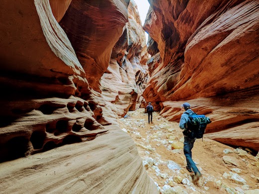
Mile after mile, the sandstone walls — hundreds of feet high on either side — have been ground to a sheen by the sheer force of water and the rocks, mud, and silt it carries violently through the canyon during the summer rainy season.

In theory, backcountry camping should be heavenly. You’re far from the madding crowds, surviving only by your wits and what you can carry. The air is crisp and clean, and the night skies contain no evidence of urban sprawl. Watching the morning sun creep over mountain peaks, John Muir once said, is worth the pain of any excursion a thousand times over.
The famed naturalist was wrong. In reality, backcountry camping — at least in one corner of southern Utah — kind of sucks.
After eight hours of hard hiking through mud bogs and freezing rivers, dinner consists of rehydrated beef stew from a foil pouch. Campfires aren’t allowed, so any clothing that gets wet during the day will remain so through morning. Sleep is fleeting at best when wrapped up like a mummy to fend off the 38-degree night air. To top it all off, you’re expected to poop into a plastic “wag bag” and carry it with you the rest of the journey.
This is what awaits ramblers on one of the most celebrated hikes in America — Buckskin Gulch in the Vermillion Cliffs Wilderness Area on the Utah-Arizona border. It’s a two-day, 20-mile trek that traverses the 13 miles of the longest and, at 500 feet near the end, deepest slot canyon in North America, perhaps in the world.
It’s also one of the most dangerous trails in America. Monsoons similar to those that carved the canyon out of the native sandstone over the millennia can pop up without warning during the late summer season, filling the canyon with water in minutes. Anything inside is instantly flotsam. There is no way out that does not require rescue crews at the surface.

Even during drier months, the trail is arduous, requiring scrambles over or between boulders that have careened down from above and blocked the passage. Freezing pools of stagnant water or thick, silty mud are everywhere on the canyon floor, which in spots is only a couple feet wide. The final seven miles of the trek require crossing the Paria river no fewer than 140 times.
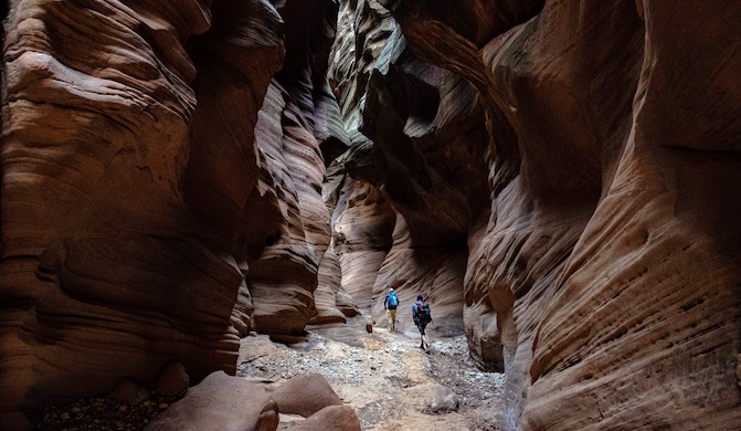
The scenery, however, is otherworldly enough to make the hardship worthwhile. Mile after mile, the sandstone walls — hundreds of feet high on either side — have been ground to a sheen by the sheer force of water and the rocks, mud, and silt it carries violently through the canyon during the summer rainy season.
Only 20 people a day are allowed to camp overnight in the 112,500-acre Paria Canyon-Vermillion Cliffs Wilderness. The handouts one gets when collecting the permit at a ranger station 30 miles east of Kanab, Utah, are full of dire warnings. There are no water sources on the trail. There’s quicksand. There’s no cellphone service. If you have a life-threatening emergency, help is “at best” many hours away. If you are lost or have a minor injury, the language insinuates, you’re just going to have to suck it up and cope.
“It may be uncomfortable, but you are expected to be self-sufficient and get yourself out of trouble,” read one brochure we were handed when we checked in on a mid-March morning recently.
To begin our trek, we left one car at the White House trailhead on the upper Paria River and the other at our starting point 15 miles away, Wire Pass. Saddled with about 35 pounds of food, water, and sleeping gear each, my two grown sons and I slipped through the narrow but short Wire Pass canyon and into Buckskin Gulch itself.
Petroglyphs carved into the wall near the main entrance attest to human activity in the area at least as long ago as the 12th century. The first known Europeans in the area were a pair of Franciscan priests looking for an overland route between Sante Fe, New Mexico, and the missions in California. Permanent settlements didn’t take hold until the 1870s.
Almost immediately, the broad canyon narrows, funneling visitors into a serpentine chasm that for the next 11 miles or so was rarely wider than an SUV. Tree trunks and other debris were wedged into the crevice 50 feet above our heads in several spots, reminders of how high the water can get in the enclosed canyon. Direct sunlight was rare at the surface.
We managed to keep our feet dry for the first several hours thanks to stepping stones placed in the numerous pools of stagnant water. About seven miles in, though, our luck ran out.
Before us was a series of mud bogs, each about 20 feet in length and covering the entirety of the canyon floor. We tried throwing some small boulders in to create a dry path through, but they disappeared as soon as they hit the surface.
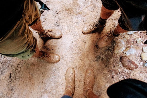
Left with no other choice, we double-tied our boots and waded in, immediately sinking up to our knees in silty muck the color and consistency of thick, clay-colored paint. For miles afterward, until the clay dried and fell off, each of our feet weighed a couple extra pounds.

At around mile eight, the second of two boulder jams in the canyon forces hikers to lower their backpacks down a ledge with a rope. Once unencumbered, we had to choose between lowering ourselves down a different rope anchored to the rock or squeezing through a slit in the rocks and making use of a makeshift ladder crafted from the trunk of a tree.
Buckskin Gulch meets the Paria River at mile 13. At this point, the trail follows a more traditional canyon, formed by a river, as opposed to a slot canyon, formed by the violent rush of flood waters. The walls of this section, dubbed the Narrows, are hundreds of feet high, but lack the dimpled texture of the slot canyon walls.
Over the course of the three miles it takes to reach a spot where the canyon widens enough to create a spot suitable for camping, the Paria River — ankle-deep in places; up to our knees in others — had to be crossed dozens of times.
The water is nearly freezing, and its color is that of cement. It is wholly unsuitable for anything other than being a nuisance. The Paria is the murkiest river in the United States, carrying as much as two pounds of mud per quart of water. Neoprene socks helped ward off hypothermia.
The final miles of the hike took us through the upper reaches of the Paria, which crosses a high plateau dating to the Mesozoic era known as the Colorado Plateau. Arches, natural amphitheaters, and sandy terraces covered with shrubs and a few stands of ground-hugging cottonwood and willow ash trees are the dominant features of the canyon at this point.
Other than raptors drifting near the canyon’s top ledges, there was little wildlife visible in mid-March. The reptiles commonly active in the summer were still hunkered down for the winter, and if any of the larger mammals — bobcats, mountain lions, and bighorn sheep among them — were following our progress, we never noticed them.

Day two was easier than day one, amounting to only seven miles over four hours. Still, it was painful. By the last mile, my own stride was about half of what it was earlier in the day and the AllTrails app told me my pace was a fourth of what it had been.
It took me two days to fully recover. Lying awake in the mummy bag that night on the river, I swore never again to embark on such a journey. It’s hotels and day hikes from here on out, regardless of what John Muir used to say, I told myself.
But after the pain had fully subsided, so had the memory of the hardships. And within a couple days I was already browsing the Recreational Equipment (REI) website and looking at backcountry permits for the Big Bend National Park in Texas and Glacier National Park in Montana.

